 |
Eye4Software Hydromagic
|
Hydrographic Survey Software for Windows, Single Beam Data Collection
|
|
|
Categories
|
|
Audio & Multimedia
Audio Encoders/Decoders, Audio File Players, Audio File Recorders, CD Burners, CD Players, Multimedia Creation Tools, Music Composers, Other, Presentation Tools, Rippers & Converters, Speech, Video Tools Business
Accounting & Finance, Calculators & Converters, Databases & Tools, Helpdesk & Remote PC, Inventory & Barcoding, Investment Tools, Math & Scientific Tools, Office Suites & Tools, Other, PIMS & Calendars, Project Management, Vertical Market Apps Communications
Chat & Instant Messaging, Dial Up & Connection Tools, E-Mail Clients, E-Mail List Management, Fax Tools, Newsgroup Clients, Other Comms Tools, Other E-Mail Tools, Pager Tools, Telephony, Web/Video Cams Desktop
Clocks & Alarms, Cursors & Fonts, Icons, Other, Screen Savers: Art, Screen Savers: Cartoons, Screen Savers: Nature, Screen Savers: Other, Screen Savers: People, Screen Savers: Science, Screen Savers: Seasonal, Screen Savers: Vehicles, Themes & Wallpaper Development
Active X, Basic, VB, VB DotNet, C / C++ / C#, Compilers & Interpreters, Components & Libraries, Debugging, Delphi, Help Tools, Install & Setup, Management & Distribution, Other, Source Editors Education
Computer, Dictionaries, Geography, Kids, Languages, Mathematics, Other, Reference Tools, Science, Teaching & Training Tools Games & Entertainment
Action, Adventure & Roleplay, Arcade, Board, Card, Casino & Gambling, Kids, Online Gaming, Other, Puzzle & Word Games, Simulation, Sports, Strategy & War Games, Tools & Editors Graphic Apps
Animation Tools, CAD, Converters & Optimizers, Editors, Font Tools, Gallery & Cataloging Tools, Icon Tools, Other, Screen Capture, Viewers Home & Hobby
Astrology/Biorhythms/Mystic, Astronomy, Cataloging, Food & Drink, Genealogy, Health & Nutrition, Other, Personal Finance, Personal Interest, Recreation, Religion Network & Internet
Ad Blockers, Browser Tools, Browsers, Download Managers, File Sharing/Peer to Peer, FTP Clients, Network Monitoring, Other, Remote Computing, Search/Lookup Tools, Terminal & Telnet Clients, Timers & Time Synch, Trace & Ping Tools Security & Privacy
Access Control, Anti-Spam & Anti-Spy Tools, Anti-Virus Tools, Covert Surveillance, Encryption Tools, Other, Password Managers Servers
Firewall & Proxy Servers, FTP Servers, Mail Servers, News Servers, Other Server Applications, Telnet Servers, Web Servers System Utilities
Automation Tools, Backup & Restore, Benchmarking, Clipboard Tools, File & Disk Management, File Compression, Launchers & Task Managers, Other, Printer, Registry Tools, Shell Tools, System Maintenance, Text/Document Editors Web Development
ASP & PHP, E-Commerce, Flash Tools, HTML Tools, Java & JavaScript, Log Analysers, Other, Site Administration, Wizards & Components, XML/CSS Tools |
|
|
Eye4Software Hydromagic 6.0
|
Eye4Software B.V.
|
|
|
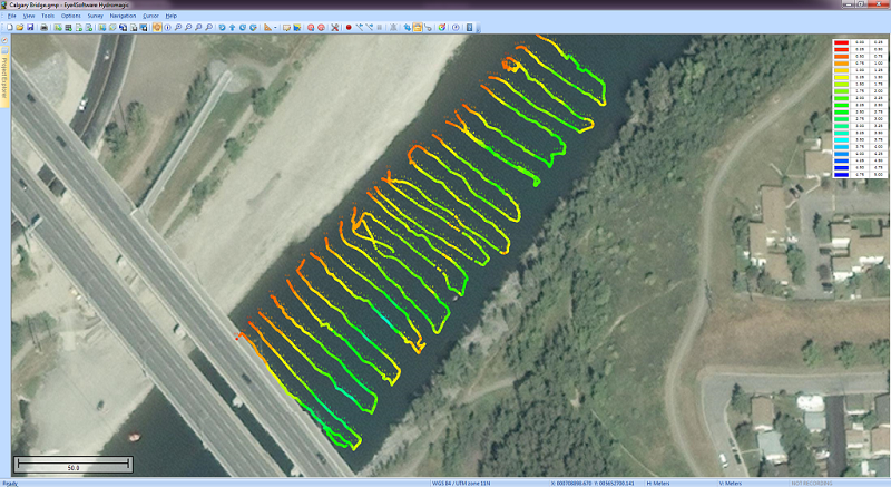
Description:Eye4Software Hydromagic is hydrographic survey software for Windows. It can be used to generare depth maps using a GPS or RTK receiver and an echosounder or fishfinder.
After recording the sounding, you can generate DTM's (Digital Terrain Models), depth contours, 3D views and cross-sections.
It offers various methods of calculating volumes of bassins, ponds, river sections and lakes.
The software is capable of reading and writing most popular CAD, GIS and nautical chart formats, including: GeoTIFF, Microstation DGN, ARC/INFO, MapInfo MIF/MID, AutoCad DXF files, IHO S57/S63 Electronic Natutical Charts, Google Earth KML/KMZ files and ESRI shapefiles.
A wide range of map projections is build in. More then 5000 map projections are built in. In addition, NTv2, NADCON and HARN correction grids are supported.
The software is also able to calculate tide levels in real time by using a RTK receiver connected to the PC. Using the antenna height, antenna offset and a geoid model, the tide level is calculated and applied to the sounding, resulting in a height values relative to the local vertical datum.
When no map is available for your area, you can use the build-in map downloading tool. Use OpenStreetMap, Google Maps or Bing maps as background maps.
Since this latest version, the software can be used to collect and process dual frequency sounding data, as well as additional sensor data, such as magnetometer data, or advanced data from echosounders, like reflectivity or bottom-loss.
Another big improvement is the use of shorelines. Shorelines can be used to add data collected near the shore, to create islands or to clip your DTM data, by just by specifying on which side of the shoreline the water is.
For the people who want to perform their survey by using planned lines, there is also good news: It is now possible to calculate a DTM or depth contours from multiple soundings or shorelines. Just press a single key to start a new line !
|
|
| Hydrographic Survey Software, Hydrographic Software, Hydrographic Survey, Bathymetry, Seafloor Mapping Software, Hydrographic Data Acquisition, Dredging Volume Calculation, Volume Calculations, Bathymetric Software, Single Beam Data Collection |
|
|
|
Top 10 programs in Business::Math & Scientific Tools category
|

|
ChemMaths
Software suitable for Engineering,Chemistry/Science, Professionals/education. |

|
Data Master 2003
Plot, edit and analyze numeric data, automate measurements and post-process |

|
Quality Window
An intuitive SQC/SPC/Event Analysis tool designed for use on the factory floor |

|
Aurora
Use LaTeX to enter math in regular word processors and presentation programs. |

|
MITCalc - Torsion Springs
Geometric and strength designs of spiral cylindrical torsion springs |

|
Complex Number Calculator Precision 45
Complex number calculator for scientists, engineers, teachers, and students. |

|
OkMap
OkMap - GPS and map Windows software for many outdoor activities |

|
MITCalc - Tension Springs
Geometric and strength designs of helical tension cylindrical springs |

|
Bersoft Image Measurement
Measures an analyzes digital images. Includes image Database. |

|
MITCalc - Pinned couplings
Geometric design and strength check of couplings using pins and clevis pins |
|
|
